Uganda Equator: Photos, Facts & Activities at Equator Line
Discover the Uganda Equator — one of Africa’s most famous landmarks. Learn its location, fun facts, activities, and what to see at the Equator line.
The Uganda Equator is one of Africa’s most iconic landmarks, marking the invisible line where the Earth splits into the Northern and Southern Hemispheres.
A must-visit for travelers exploring Uganda, this famous stopover is a highlight for those journeying to western destinations like Queen Elizabeth National Park or Lake Mburo National Park.
Whether you’re snapping photos at the Equator sign, marveling at the Uganda Equator water experiment, or shopping for local crafts, the Equator crossing in Uganda offers a unique blend of fun, science, and culture.
In this guide, we’ll explore where the Equator is in Uganda, its significance, top activities, and fascinating facts, including which lakes and island districts it crosses. Ready to stand on both sides of the world? Let’s dive into the Uganda Equator experience!
Where is the Uganda Equator Located?
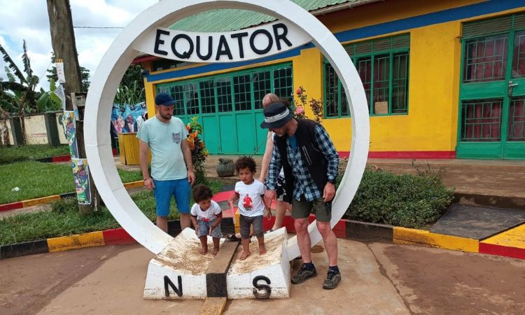
The Equator line in Uganda is most famously marked at Kayabwe in Mpigi District, approximately 72 km (1.5 hours) from Kampala along the Kampala–Masaka Highway. This is the primary tourist spot, featuring iconic Equator signs and a vibrant visitor area. Its coordinates are roughly 0°00’N, 32°00’E, making it a bucket-list stop for travelers.
Other notable Equator markers in Uganda include:
- Uganda Equator Kasese: A lesser-known marker near Kasese town, often visited by those heading to Queen Elizabeth National Park.
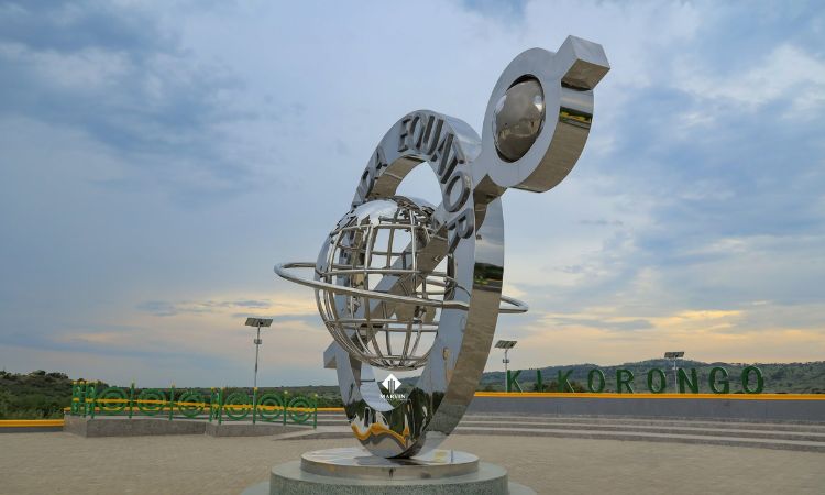
- Queen Elizabeth National Park: The Equator crosses the park, with a marker near the Kikorongo area.
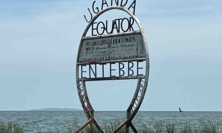
- Uganda Equator Entebbe: A smaller marker exists near Lake Victoria, though it’s less frequented by tourists.
How Many Districts Are Crossed by the Equator in Uganda?
The Equator crosses 13 districts in Uganda, including Mpigi, Kasese, Rubirizi, and Kalangala (an island district). The island district crossed by the Equator in Uganda is Kalangala, located in Lake Victoria, where the Equator runs through some of its islands, such as Bugala Island.
Lakes Crossed by the Equator in Uganda
The Equator crosses Lake Victoria, Africa’s largest lake, making Uganda one of the few countries where the Equator intersects a major water body. This adds to the region’s geographical allure, especially for those visiting Kalangala or Entebbe.
What to Expect at the Uganda Equator
Visiting the Uganda Equator is both educational and entertaining, offering a mix of science, photo opportunities, and local culture. At the main Kayabwe site, here’s what you’ll find:
- Iconic Equator Signs: Perfect for photos, these circular markers let you stand with one foot in each hemisphere.
- Uganda Equator Water Experiment: Watch local guides demonstrate the Coriolis effect, showing how water swirls clockwise in the Northern Hemisphere, anticlockwise in the Southern Hemisphere, and straight down at the Equator line. While scientifically debated, it’s a fun and engaging activity.
- Zero-Gravity Illusion: Experience the illusion of weighing slightly less at the Equator due to Earth’s shape, as guides may demonstrate with simple experiments.
- Souvenir Shops and Craft Markets: Browse Equator souvenir shops in Uganda for handmade jewelry, wooden carvings, and clothing.
- Equator Café and Curio Shop: Enjoy a coffee, snack, or meal at the café while soaking in the vibrant atmosphere.
- Equator Crossing Certificate: Some vendors offer a certificate to commemorate your visit, a fun keepsake for travelers.
The Kayabwe site is a lively stop, bustling with tourists, especially those en route to Lake Mburo or Queen Elizabeth National Park.
Things to Do at the Uganda Equator
The Uganda Equator offers a range of fun and educational activities for visitors. Here are the top things to do at the Uganda Equator:
- Take Photos Across Hemispheres: Capture iconic shots standing on both sides of the Equator line. The signs make for memorable social media posts.
- Watch the Water Rotation Demonstration: Be amazed by the Uganda Equator water experiment, a crowd-pleaser for all ages.
- Shop for Local Crafts: Visit Equator souvenir shops in Uganda for unique gifts like beaded jewelry, baskets, and traditional fabrics.
- Dine at Equator Café: Relax with a meal or drink while enjoying the scenic surroundings.
- Learn About Uganda’s Geography: Engage with guides who explain the Equator’s significance and its impact on Uganda’s climate and culture.
For a deeper Uganda experience, explore related destinations like Kampala City Tours or book our 3 Days Queen Elizabeth National Park Safari for a full adventure.
Best Time to Visit the Uganda Equator
The Uganda Equator is accessible year-round, but the dry seasons (June–August and December–February) are ideal for comfortable travel and clear photos.
During these months, the weather is sunny and roads are in better condition, making the drive from Kampala or Entebbe pleasant.
The wet seasons (March–May and September–November) are still viable, but expect occasional rain, which may affect outdoor activities.
How to Get to the Uganda Equator
Reaching the Uganda Equator is straightforward, especially the Kayabwe site:
- From Kampala: Drive 72 km (1.5 hours) along the Kampala–Masaka Highway. The Equator is a popular stopover for those heading to Lake Mburo National Park or Queen Elizabeth National Park.
- From Entebbe: The drive is slightly longer (about 2 hours), passing through Kampala or alternative routes.
- Transport Options: Choose a self-drive car hire, join a guided tour, or book a safari package that includes the Equator as a stop.
The Uganda Equator Kasese marker is accessible via the Kampala–Fort Portal–Kasese route, ideal for those visiting western Uganda.

Nearby Attractions & Stopovers
The Uganda Equator is perfectly positioned for combining with other attractions:
- Mpambire Drum Makers Village: Located near Kayabwe, this village showcases traditional Ugandan drum-making.
- Lake Mburo National Park: Just a few hours’ drive, ideal for a wildlife safari with zebras and impalas.
- Masaka Town: Explore local markets and cultural sites en route.
- Roadside Fruit Stalls and Craft Markets: Pick up fresh produce or handmade souvenirs along the highway.
Travel Tips for Visiting the Uganda Equator
- Bring Cash: Mobile money and cards may not be widely accepted at souvenir shops or the café.
- Stay Vigilant: The Kayabwe site can be busy, so keep an eye on your belongings.
- Wear Sunscreen and Light Clothing: Midday temperatures at the Equator can be high, especially in the dry season.
- Arrive Early: Beat the crowds and enjoy clearer photo opportunities in the morning.
Interesting Uganda Equator Facts
Here are some engaging Uganda Equator facts to enrich your visit:
- Uganda is one of only 13 countries crossed by the Equator globally.
- The Equator passes through 13 districts in Uganda, including Mpigi, Kasese, Rubirizi, and Kalangala.
- Lake Victoria, Africa’s largest lake, is crossed by the Equator, making it a unique geographical feature.
- The island district crossed by the Equator in Uganda is Kalangala, with Bugala Island being a key spot.
- At the Equator, the sun rises and sets quickly, resulting in nearly equal day and night lengths year-round.
- You weigh slightly less at the Equator due to Earth’s oblate shape, creating a minor gravitational difference.
FAQs About the Uganda Equator
Q1: Where is the Equator found in Uganda?
A1: The main Equator line is in Kayabwe, Mpigi District, along the Kampala–Masaka Highway, with additional markers in Kasese and Queen Elizabeth National Park.
Q2: Is it worth visiting the Equator in Uganda?
A2: Yes, it’s a fun and educational stop with photo opportunities, the Uganda Equator water experiment, and local crafts.
Q3: How far is the Equator from Kampala?
A3: The Kayabwe Equator is about 72 km (1.5 hours) from Kampala, a perfect stopover on the way to western Uganda.
Q4: Which lakes are crossed by the Equator in Uganda?
A4: The Equator crosses Lake Victoria, Africa’s largest lake, in the Kalangala district.
Q5: Which island district is crossed by the Equator in Uganda?
A5: The Kalangala district, particularly Bugala Island, is crossed by the Equator.
Conclusion: Experience the Uganda Equator
Visiting the Uganda Equator is a must for anyone exploring the Pearl of Africa. Whether you’re snapping photos at the iconic signs, marveling at the Uganda Equator water experiment, or shopping for souvenirs, this landmark offers a fun and educational break on your journey.
Perfectly located on the route to Queen Elizabeth National Park or Lake Mburo, it’s an ideal stopover for safari-goers and curious travelers alike.
Don’t miss this chance to stand on both sides of the world! Book your Uganda adventure today with our customized safari packages or car hire services and make the Uganda Equator a highlight of your trip!